An Alternative Tool for Inspecting Telecom Towers
Author and Photographer: Aja Lucero
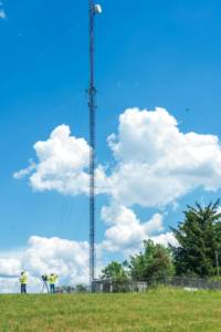
Here at ARE, we move quickly and efficiently. Operations begin once an open opportunity has been converted to a Closed-Won opportunity in our Sales CRM. But what does that mean? What does it take to plan, mobilize, collect UAS LiDAR data, and provide deliverables? Well, let’s find out! Let’s take a look at one of our most recently completed projects for TranSystems Corporation. The project scope was a UAS LiDAR scan of 15 telecom tower structures on MassDOT (Massachusetts Department of Transportation) properties. We are fortunate to have an excellent working relationship with MassDOT, so we hit the ground running.
Planning
Once ARE has been given the green light, it’s full steam ahead! It all starts with our in-office Operational Plan development which includes a risk assessment, acquiring authorizations, and figuring out what flight pattern will best suit the project. First, we develop a risk assessment based on airspace, hazards in the area, pilot experience, and environmental factors. If the area of interest, or in this case the structure, is located in controlled airspace, authorization from the FAA will need to be obtained prior to flight operations. We’ll also obtain permission from the landowner (MassDOT) to launch and land on their property.
The next step is to create the flight plans with consideration of the geographic area of the project site. We’ll use publicly available LiDAR to evaluate terrain and structure heights in the area. For LiDAR scans, we use “terrain follow.” This means the drone maintains a relatively constant altitude above ground level (AGL) in order to make a consistent data set while performing cross-hatches over the Area of interest (AOI) at a safe altitude. Once our UAS team has an operational plan, it’s time to get out into the field!
On-site Set up and Assessment
The first step in any LiDAR data collection is to set up the Base Station. It takes about 2 hours for the Base Station to complete its collection of satellite GPS points. It’s crucial to set it up in an open area where it will not be disturbed by other people, animals, or weather changes and have a clear view of the surrounding sky. We were lucky on this particular project that we were able to set up the Base Station on top of a very open field. Not a bad view from the top either!
The next step for our UAS pilots is to take an on-the-job analysis of the surrounding terrain and adjust the flight plan accordingly. No matter how detailed your pre-planned flight plan is, there is nothing like using your own two eyes to visually inspect the area in the field. Once the analysis is complete, it’s time to set up the drones!
Flight Operations
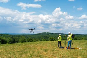
On this particular mission, we’ll utilize two drones from our fleet—the DJI Phantom 4 Pro and DJI M600 Pro. The Phantom 4 Pro is the pre-flight scouting drone for this project and is used to ensure we have a good line of sight as well as keep the mission on track. The M600, geared with our Phoenix LiDAR system is used to complete the LiDAR Scan and communicates directly with the ground station. Projects like these are all about safety and teamwork in tandem. The Remote Pilot in Command (RPIC) is in constant communication with the Sensor Operator. Before any flight takes place, the RPIC runs through our extensive safety checklist with the entire crew. In this case, there are three ARE employees and one MassDOT employee. Now it’s time for take-off, “CLEAR”!
Once the aircraft is in the air, the RPIC manually flys a few figure eights to ensure the GPS accuracy is on point and the Inertial Measurement Unit (IMU) is calibrated. The margin of error on the M600 GPS is about 2-3cm. The total flight time for this structure is about 7-8 minutes at 250ft AGL. Once the mission is complete and ready for landing, the Sensor Operator assists the RPIC by ensuring the designated landing zone is clear. When the drone lands on the ground, the team lets it sit tight for five minutes. This lets the Fiber Optic Gyro IMU static align to ensure data accuracy. This last step is crucial for post-processing. After a few minutes, the UAS team is ready to break everything down, pack up, and relocate to the next structure!
So, what’s next? Well, that would be processing the dataset, of course! Come back soon for a blog on ARE’s deliverables process!
Don’t forget to follow us on Social Media for additional updates and see what we’re up to next!
![]()
![]()
![]()
![]()