ARE Partners with Visual Intelligence
Delivering Millimeter-Class UAS (drone) Data for Rail and Utility Engineering Services

ARE and Visual Intelligence announce a partnership to bring the benefits of millimeter-class UAS (drone) data and engineering analysis to the Rail and Utility industries.
UAS (drone) data is continuing to provide an important role in infrastructure management by improving safety and efficiency of inspections. For additional use cases among engineering departments, the datasets and 3D models have provided minimal value. To make drone data truly useful for engineering purposes, a greater degree of accuracy and coverage is required
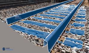
In working with Visual Intelligence, ARE will now be able to capture engineering-grade datasets on infrastructure, such as rail bridges and utility substations. ARE will provide unprecedented services to customers in the rail and utility sectors allowing for better analysis of structures. With data that is 10-20 times more accurate than mobile LiDAR technologies and 50-100 times more accurate than single camera commercial drones, this new class of UAS data opens the door to an unexplored category of offerings that serve engineering workflows and benefit analysis across an asset’s complete lifecycle.
“We believe this new class of drone data will put ARE on the leading edge of infrastructure inspections, condition assessments and design solutions,” said Dave Anderson, PE, CEO at ARE. “With engineering-grade accuracy, we’ll unlock the full potential of digital twins, artificial intelligence and inspection automation, placing our customers on a path for success in the new digital infrastructure era.”
In partnering with Visual Intelligence, ARE will have access to VI’s proprietary combination of dual sensor technology, collection management software, and powerful analytics engine. This technology is expected to enable new forms of automation, maintenance efficiencies and engineering analysis.
“ARE’s knowledge of infrastructure lifecycles, its proven engineering expertise, and its progressive approaches to solving customer challenges is a natural fit for our technology in the rail and utility industries,” said Ted Miller, Founder of Visual Intelligence and former Chairman, CEO of Crown Castle International (NYSE: CCI). “Currently delivering UAS solutions in 46 states across the US, this partnership will bring the value of millimeter-class data to rail and bridge engineering analysis across the country.”
ABOUT VISUAL INTELLIGENCE
![]()
Visual Intelligence is a unified drone sensor and software automation platform that digitizes physical infrastructure with millimeter accuracy to reliably deliver 3D, engineering-grade asset intelligence.
Using patented dual-sensor drone technology and proprietary enterprise software, Visual Intelligence generates billions of data points to map exponentially more measurable surface area than any alternative aerial or ground-based method. Our unique sensor-software pairing is the first industry solution that enables enterprises to capture and execute around engineering-grade digital twins. By maximizing data fidelity and coverage, we are exponentially increasing the ability of artificial intelligence to automate performance capacity at an engineering level, feeding insights upstream and across new business units, vendors and geography.
To learn more, visit https://visualintelligenceinc.com
Don’t forget to follow us on Social Media for additional updates and see what we’re up to next!
![]()
![]()
![]()
![]()