 Author: Katelyn Wood, Marketing Coordinator
Unmanned Aerial Systems (UAS or Drone) provide an alternative approach to traditional terrestrial and aerial acquisition mapping and ground-based surveys. Picking up where traditional methods of acquisition are limited, such as safety, time, expense, and project site accessibility, UAS unlock new opportunities for acquiring geospatial information via LiDAR and photogrammetry.
LiDAR and photogrammetric techniques provide integral solutions for customers at ARE-AirShark. Project criteria including environmental conditions, delivery specifications, budgets, and the ultimate purpose of the data collected dictates which application is better suited. Neither LiDAR nor photogrammetry is better than the other, both having their individual benefits in aerial data collection and processing.
UAS LiDAR Data Acquisition
Utilizing UAS LiDAR, data can be collected from below the tree line and through dense vegetation. The image below showcases an example of UAS LiDAR. This project aimed to support a hydrologic study in evaluating alternatives to reduce stormwater runoff, erosion, and road damage from a steep and complex drainage area. The study site is located in a steep hillside that extends down a road with small pockets of development, dense forest, an abandoned railbed, a gravel road, and a riparian wetland. The goal of the project is to develop concept designs that address sources of runoff within the 80-acre drainage area causing extensive erosion and damage to the road in question, as well as significant sediment loading to a riparian wetland area and river.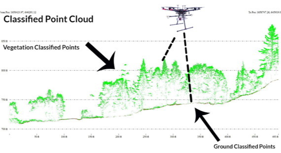
As demonstrated through this image to the left, LiDAR is used to assess the terrain under a dense tree canopy utilizing a Riegl miniRANGER LiDAR sensor with a measurement rate of 100,000 pulses per second. The drone flies at 200-400 ft above the ground, capturing data with a density of 80-100 points per square meter, at an accuracy of 2-5 cm.
LiDAR
LiDAR, which stands for Light Detection and Ranging, is a remote sensing method that uses light in the form of a pulsed laser to measure ranges (variable distances) to the Earth. These light pulses—combined with other data recorded by the airborne system—generate precise, three-dimensional information about the shape of the Earth and its surface characteristics (oceanservice.noaa.gov).
Below are several products and applications that our GIS specialists produced from raw LiDAR data collected by the ARE-AirShark UAS flight team.
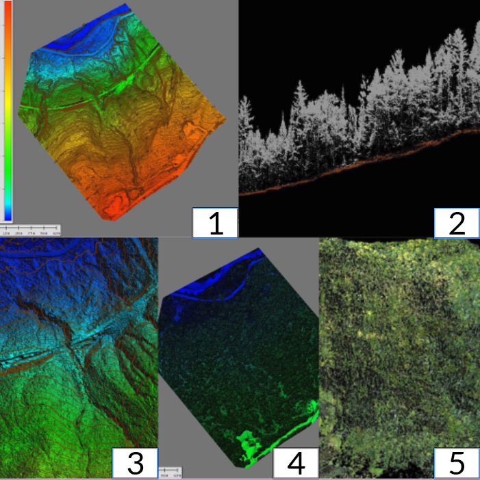 Digital Elevation Model (DEM): A Digital Elevation Model, which is a representation of the bare Earth (no vegetation or buildings), is generated using just the ground points from a classified point cloud and triangulating those points to create a raster. (See Image 1)
Point Cloud on Slope: A classified point cloud is created using automated routines and manual cleanup to code ground, vegetation, building, etc. into each georeferenced point. (See Image 2)
Elevation Contours: Derived from a LiDAR generated DEM, a contour is a line representing a constant elevation across a landscape. (See Image 3)
Digital Surface Model (DSM): A DSM is a representation of the Earth’s surface generated by filtering a raw LiDAR point cloud so that only first returns are analyzed, with the resultant product being a highly accurate representation of surface reality. (See Image 4)
Colorized Point Cloud: With the UAS capturing RGB (Color) images simultaneously, the point cloud can be colorized to help discern complex features on the ground. (See Image 5)
Additional uses of UAS LiDAR include construction site planning, engineering design, drainage, planning excavation, forest management, coastline management, transportation infrastructure planning, volumetric measurements, and energy planning.
Photogrammetry
Photogrammetry is the art and technology of obtaining reliable information about physical objects and the environment through processes of recording, measuring, and interpreting photographic images and patterns of recorded radiant electromagnetic energy and other phenomena (Wolf and Dewitt, 2000; McGlone, 2004). Photogrammetry is primarily concerned with making precise measurements of three-dimensional objects or terrain features from two-dimensional photographs.
Two general types of photogrammetry exist: aerial and terrestrial. Small-format aerial photogrammetry takes place between these two types, combining the aerial vantage point with close object distances and high image detail.
ARE-AirShark utilizes photogrammetric techniques with a range of high-resolution Electro-Optical (EO) sensors and UAS. These sensors are equipped with wide-angle lenses and can easily collect color and light information in the form of pixels. The aircraft platforms used vary depending on the client’s needs and the resolution requirements. Our highly experienced UAS pilots, data processors and GIS specialists, provide orthomosaic raster images, Digital Surface Models, contours and volumes in a format that clients can work with.
Applications for photogrammetry include The measuring of coordinates; The quantification of distances, heights, areas, and volumes; The preparation of topographic maps; And the generation of digital elevation models and orthophotographs.
Photogrammetry Example
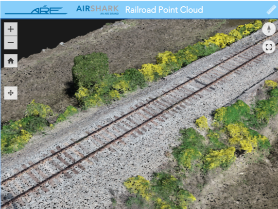
Photogrammetry collected by UAS was used to generate the interactive point cloud (image to the right) as a safe, low-impact solution to right-of-way analysis. The use of UAS to obtain this data improves safety by not being on the railroad compared to traditional survey methods and saves overall time. The image consists of 660 photos stitched together. Our engineers used this data to support analysis of stormwater from recent railroad construction.
Photogrammetric processes can also be applied to waste management facilities, college campuses, coastal mapping and energy-related projects.
LiDAR and Photogrammetry Compared
There are concrete differences between photogrammetry and LiDAR. LiDAR is a direct (active) measurement whereby a laser directly contacts the Earth’s surface and arrives back to the sensor creating a point cloud. Photogrammetry entails capturing images from the UAS and stitching the images together creating a point cloud of the Earth’s surface. It’s important to take a more in-depth look at both applications to make sure there is a full understanding before deciding on the method of data collection for a particular project.
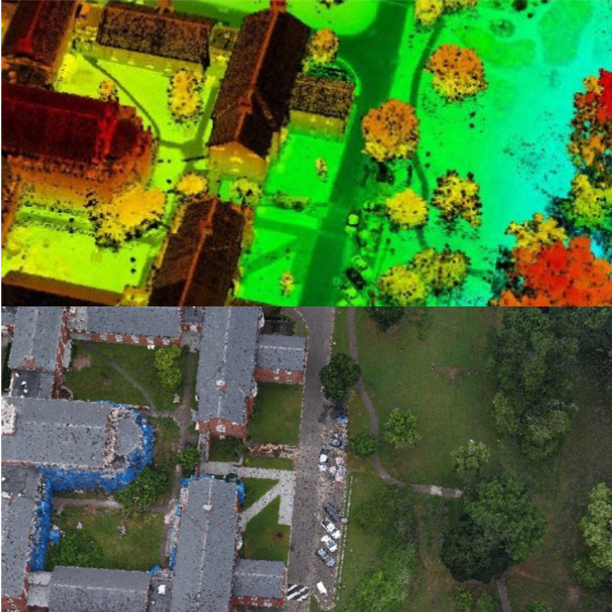
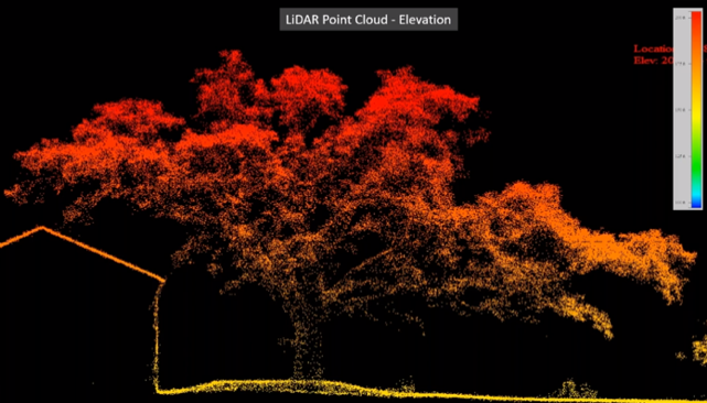
Below are two examples of LiDAR vs. photogrammetry. These images were captured on the same site from two different flights. The top image is a point cloud image collected using the photogrammetric method taken of the top of a tree with the UAS. Data was able to be collected, but ground data was not collected at vegetated areas. Photogrammetry can work well with bare surfaces and collecting surface data of structures but is not as effective for vegetated areas. The bottom image presents processed LiDAR data of the same area. The laser returns enable detailed 3D modeling from both vegetative surfaces, bare earth (Ground) as well as the heavily vegetated structure details (House). The ground information was collected and processed.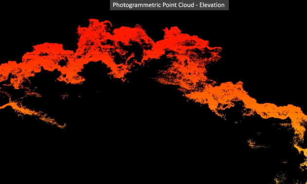
Conclusion
When it comes to LiDAR and photogrammetry, it is important to know the differences and utilization of both data collection methods, as well as limitations and benefits. LiDAR is commonly used for surveying fine features such as power lines and mapping of dense vegetated areas. Photogrammetry is often used for situations that require visual data such as agriculture and construction sites. With new mapping technologies that are developing every day, ARE-AirShark is eager to immerse in these new technologies and to constantly enhance and improve our data collection methods.
Citations:
Aber, J. S., Marzolff, I., & Ries, J. B. (2010, May 14). Photogrammetry. Retrieved from https://www.sciencedirect.com/science/article/pii/B9780444532602100031
US Department of Commerce, & National Oceanic and Atmospheric Administration. (2012, October 1). What is LIDAR. Retrieved from https://oceanservice.noaa.gov/facts/lidar.html