How UAS LiDAR Data Helps Utility Companies
Author: Andrew Mallin

Throughout the last century, utility providers maintained and inspected their networks through a boots-on-the-ground process that has typically required inspectors to be physically present along the length and breadth of the utility network. In addition to being legislatively required of the utility provider, regular inspection of transmission lines reduces the number of power outages and identifies faults in overhead powerlines that if left unchecked can lead to deadly ground fires. Inspections also enable better measurement of the throughput of a transmission line which can be used to potentially see a higher rate of return on a line.
Unmanned Aerial Systems (UAS), also known as UAV or drones, are now being adopted for widespread usage by a variety of industries but one standout application of UAS is for inspecting utility lines. By using UAS, the inspector has the ability to take high-resolution pictures and videos of transmission and distribution lines without putting the inspector at risk. However, pairing UAS inspection with LiDAR technology drives the benefits of UAS inspection for utilities to a higher level. With UAS LiDAR mapping, users can now generate complete 3D views of utility assets, roads, buildings, vegetation, and bare earth to improve asset management systems.
Benefits of UAS LiDAR mapping in Utility line assessment:
- Easily map areas which are difficult to access, such as steep terrain, unstable slopes or wetlands
- Assess pole height and lean while also capturing larger areas for accurate geotechnical data.
- By quickly identifying potential problems or at-risk assets, owners can address where safety concerns in the network are most urgent.
- Reduce noise pollution, safety risks, and costs of low-flying manned aircraft
- Identify and map infrastructure obstructed by heavy vegetation.
- Generate a complete 3D map of electric assets across a powerline and proposed powerline corridors.
- Generate digital surface models and bare earth models for site planning and drainage assessments.
- Develop structure and line rating assessments.
- Monitor old and/or overloaded transmission lines by capturing line sag.
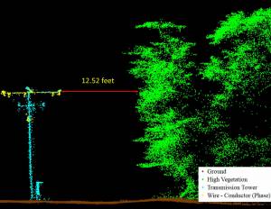
Project Example
ARE’s UAS team mapped three miles of utility Right-of-Way in Salem, NH with LiDAR. ARE provided a classified point cloud including ground, vegetation, phase conductors, transmission towers, road surface, and buildings, which could be filtered out and hidden as needed. Data files were imported into PLS-CADD to seamlessly fit the clients’ workflow to provide existing condition information. This improved the design process of the transmission system upgrade.
In the past, this type of project would require a helicopter to complete the LiDAR scan. ARE was able to complete the project for about half the price of a helicopter and with higher resolution and point cloud density.
It’s a good time of year to be thinking about using UAS for Utilities Inspection; the leaves are off, and we’re ready to fly for you!