Author: Andrew Mallin, UAS/GIS Solutions Specialist
Our clients face various challenges and to help them make informed decisions, ARE Corp. flies a variety of sensors onboard our UAS platforms. Today, we’ll be addressing the applications and benefits of aerial thermal imagery.
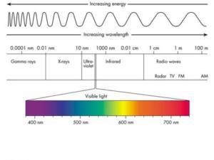
At ARE, we fly near-infrared thermal cameras that measure infrared radiation, or infrared light. This electromagnetic radiation is invisible to the human eye and only sensed by humans as heat.
Is thermal imagery the same thing as Night Vision? No; while night vision takes low levels of visible light and amplifies the signal to produce a picture, thermal imaging only senses infrared radiation in the non-visible spectrum, which means thermal imaging sensors work in both daylight and complete darkness.
Using proper thermographic techniques, a thermal image can be analyzed to determine the surface temperatures of objects. It is important, however, that the analyst understands the basics of thermography and camera functionality to avoid misinterpretation.
What is thermal imagery used for? Thermal imagery is great for remotely detecting:
- leaks in pumps, lines, and valves
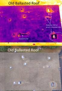
- assessing the thermal storage capabilities of rooftops and various other structures
- measuring the energy efficiency of structures through displayed heat loss
- pollution detection
- quality control of production environments
- moisture present in unexpected places
- delaminated concrete
- …and many other applications
Project Example
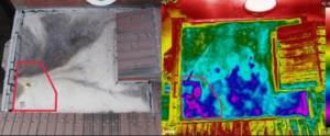
ARE conducted a roof inspection utilizing an RGB camera and a FLIR thermal camera to identify areas of concern. The building was particularly challenging for normal inspection methods due to multiple rooftop levels and steep angles.
Specifically, the objective was to identify thermal anomalies in flat asphalt areas. This could indicate elevated moisture content and help guide crews to investigate specific areas. With both sensors on the same drone, the flight crew simultaneously captured imagery of the 20,000+ sq. ft. rooftop in an hour and a half. The team analyzed the data and delivered RGB images, raw thermal images, edited thermal images, and an inspection report. The report identified areas of concern, saving our client from renting a bucket truck for an extended period of time to have crews inspecting all of the roof surfaces.
If you’d like to learn more or to see a demo of our thermal imaging capabilities, UAS mapping services, or geospatial (GIS) data management workflows, please contact us.